Contents
Index
Starting a Job
Open GeoCadastre and select FILE-NEW which opens the Job settings window
Fill in the details as necessary
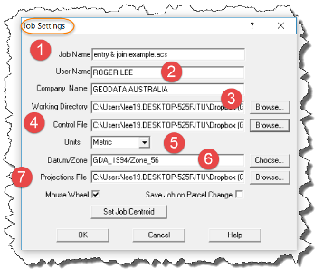
- Job Name is mandatory
- User Name & Company Name are arbitrary but once used will be the default values until they are changed manually
- Working Directory is not mandatory and will be inserted once the file is saved
- Control file can be added at the time real control is added
- Units - Metric is the default and USA an option. USA is only selected if the job is measured in US Survey Feet.
- Datum/Zone is selected from the dropdown menu which the program reads from the Projections File (selected below)
- Projection File will be selected from the installation folder, where the GeoCadastre.exe file resides
After setting the job up with these settings the next step is to add a parcel or parcels.
To do this select one of the available options - New Parcel in Plan in this example
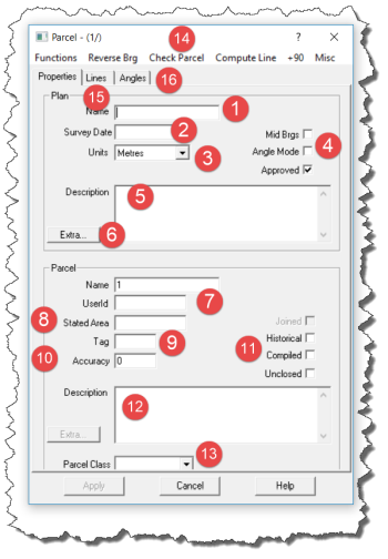
- Insert Plan Name
- Insert Survey date which is important as the program uses this to establish the parcel accuracy
- Units - the options are Metres, Feet, Links & US Survey Feet
- Mid Bearings and Angle mode are only selected where appropriate (generally NT & WA)
- Plan description is optional but it is worth inserting.
- Extra Plan Attributes. Click to expose, attributes are relevant to Land XML & the NSW ePlan data model
- User ID is a free text field for operator use.
- Stated Ares - enter from the plan
- Tag is used arbitrarily for a parcel type
- Accuracy is added by the program (see (2) above ) and can be edited if required.
- Flags to set parcel as Historical, Compiled or Unclosed as appropriate.
- Parcel Description is useful to add notes in relation to the parcel which might have been revealed during data entry. It is not mandatory.
- Parcel Class is specific to Northern Territory
- Various tools for parcel manipulation
- Lines - exposes the Lines table where parcel boundary bearings & distances are input
- Angles Flag changes the Lines Table format for use where angles rather than bearings are used (West Australia)